


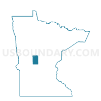
Ward Twp. Voting District, Todd County, Minnesota
About
Outline

Summary
| Unique Area Identifier | 604641 |
| Name | Ward Twp. Voting District |
| County | Todd County |
| State | Minnesota |
| Area (square miles) | 36.26 |
| Land Area (square miles) | 35.87 |
| Water Area (square miles) | 0.40 |
| % of Land Area | 98.91 |
| % of Water Area | 1.09 |
| Latitude of the Internal Point | 46.15780080 |
| Longtitude of the Internal Point | -94.84322000 |
Maps


Graphs
Select a template below for downloading or customizing gragh for Ward Twp. Voting District, Todd County, Minnesota


Neighbors
Neighoring Voting District (by Name) Neighboring Voting District on the Map
- Eagle Valley Twp. Voting District, Todd County, MN
- Fawn Lake Twp. Voting District, Todd County, MN
- Germania Twp. Voting District, Todd County, MN
- Hartford Twp. Voting District, Todd County, MN
- Iona Twp. Voting District, Todd County, MN
- Little Elk Twp. Voting District, Todd County, MN
- Moran Twp. Voting District, Todd County, MN
- Turtle Creek Twp. Voting District, Todd County, MN
Top 10 Neighboring County Subdivision (by Population) Neighboring County Subdivision on the Map
- Hartford township, Todd County, MN (662)
- Fawn Lake township, Todd County, MN (555)
- Eagle Valley township, Todd County, MN (541)
- Moran township, Todd County, MN (508)
- Germania township, Todd County, MN (500)
- Iona township, Todd County, MN (490)
- Ward township, Todd County, MN (447)
- Turtle Creek township, Todd County, MN (295)
- Little Elk township, Todd County, MN (285)
Top 10 Neighboring Unified School District (by Population) Neighboring Unified School District on the Map
- Staples-Motley School District, MN (10,060)
- Eagle Valley Public School District, MN (2,805)
- Browerville Public School District, MN (2,325)
Top 10 Neighboring State Legislative District Lower Chamber (by Population) Neighboring State Legislative District Lower Chamber on the Map
Top 10 Neighboring State Legislative District Upper Chamber (by Population) Neighboring State Legislative District Upper Chamber on the Map
Top 10 Neighboring 111th Congressional District (by Population) Neighboring 111th Congressional District on the Map
Top 10 Neighboring Census Tract (by Population) Neighboring Census Tract on the Map
- Census Tract 7904, Todd County, MN (3,468)
- Census Tract 7903, Todd County, MN (3,182)
- Census Tract 7902, Todd County, MN (2,686)